Mid-June of 2005, my parents and I were trying to come up with an idea for something to do during my impending summer holidays from study. For some reason having “something to do” during holidays is a good thing, though I can't say I know why that is. Anyway, we came up with a tour of the highlights of the Northern Territory.
We stayed in the flat I use during semester the night before we were to fly out from Brisbane to Alice Springs. Of course, my parents took the double bed in my room, and I was relegated to the spare room with its bed that my feet hang four inches over the edge of. Anyway, with a 5 AM start we rushed to the airport where we got our bags checked, and then waited for an hour or two. It's the thing you do at airports...
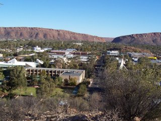
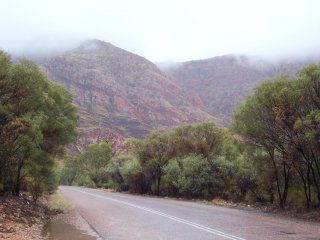
A three hour flight, and at about 11 AM local time we arrived in Alice Springs. It's red out there. And dry. And cold, in wintertime. Of course, where-ever there is the slightest hint of water, the vegetation grows and occludes the red dirt—it's only out in the desert that you can clearly see how red the stuff really is. And the desert isn't all that common in the major townships; mostly it's just arid, which means it's covered in light-brown (and sharp) spinifex.
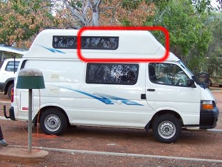
After arriving we picked up a camper-van rental. The plan was to drive the van around the red centre seeing the sights, then head north up to Kakadu and Darwin to... see the sights there. It was to be our living quarters for the following couple of weeks.
I drew a red line around the roof of the van in this photo. Technically speaking, there are three beds in that van—two on the bottom where the seats fold out, and one up the top (outlined) with a board that pulls out. I say “technically” since this third bed was honestly designed for a child: a compartment six feet in length and two feet high is fine for a kid to clamber into at bedtime, but a six foot tall adult would be forgiven for feeling a bit cramped. Of course, my parents got the bottom beds and I got to crawl and contort myself up onto the ledge above. I could barely fit. The front tapers down and tries to crush your feet, and for the first few nights I was worried that I'd work my way back over the ledge in my sleep and wake up teetering over the edge. That never did happen, but I still got a few-odd bruises trying to get up there.
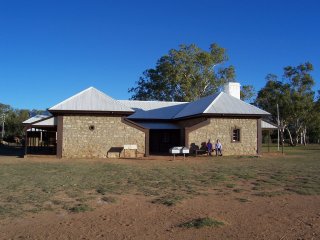
After getting some provisions for the trip (I had a feeling we were getting too much stuff, but what would I know?) we headed out to the old telegraph repeater station at Alice Springs. This is where people made meaningful beep-beep noises to each other across long distances of wire. Messages used to be transmitted north/south by going through a number of stops along the way where there would literally be a guy listening to the incoming message, write it down, then beep it out again to the next stop. Eventually they worked out an automatic repeater system to do the job (obviously) so it's a historical site now.
We didn't have much time at the telegraph station—they kicked us out as the sun was going down—so we overnighted in Alice Springs. Even with the thirty minute time difference the sun goes down and gets up much later there than we are used to on the east coast.
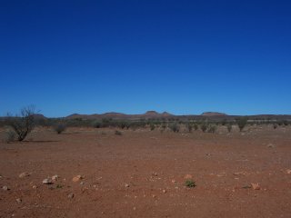
We started our trip down to Uluru, 450 km southwest of Alice Springs. On the way we made a detour to the Henbury Meteorite Craters. It's a few kilometers off the highway, along a nasty dirt road—the bumpiest, shudderiest, corrugated-est road I'd ever driven on. The only smooth bits were in the soft sandy stuff right at the edge of the road (when they were there at all).
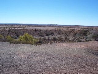
Once you get to the main crater site (battered and shaken) it's actually quite a big hole in the ground. Think about the thump that would've caused a hundred meter diameter chunk of dirt to be thrown up into the air. That's a big thump.
There's a walk that takes you around the biggest crater, and just to the side of it there are about five smaller craters. Apparently whatever fell down fragmented not far from the ground, and the fragments made their own individual craters.
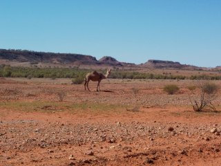
On our way out back to the highway we came across a pack of wild camels wandering across the road. You don't find them everywhere out here, but it isn't surprising to see a group or two of them as you hurtle along the highway or over a severely corrugated road.
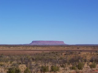
Back on the highway towards Uluru, we passed Mount Connor. It's not Uluru, it just looks a bit like it from a distance. It's just as high, but it's a regular dirt and rock mountain that's had its top cut off, or something, and it isn't just a single rock sticking up out of the ground like Uluru. Still strange.
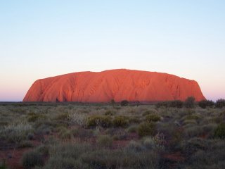
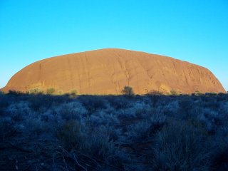
And then we hit Uluru, which us white folks called Ayer's Rock until the Aboriginals were given the land back. The rock is big. Honestly. You have little hope of getting a good idea of just how damn big the thing is from a photo. This was taken from several hundred meters away as the sun was setting—we had arrived just in time to watch the sunset.
We stayed the night in Yulara, a small town just outside the Uluru-Kata Tjuta National Park that caters to all the tourists. Given the popularity of Uluru, it was unsurprisingly packed.
Side note: Staying at Yulara, we'd left a bucket under the van to catch the water from the sink as it drained, because we're good mindful travellers, and in our rush to get out early in the morning to see Uluru as the sun rose, we reversed over it. Oops. At least, that's what we think happened, since we didn't even realise it was missing until we tried to find the bucket later that day, long after we'd left the area. (Now we owe the rental company a bucket.)
Anyway, here's the opposite side of Uluru, not long after sunrise. The rock itself isn't as red as some photos would have you believe, it's more orange. Still a bloody big rock.
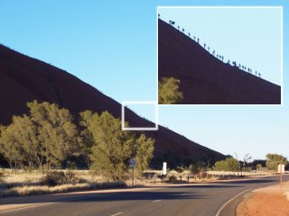
Looking along a side of Uluru might give a better idea of just how big the damn thing is. Those little dots are people. It's a big, steep climb to the top, and the Aboriginals try their best to discourage people from doing it. Something about it being a sacred site (sacredness has never been a particularly good argument for anything, in my eyes). You can see in the photo how many people actually take any notice.
There are even regions around the base of the rock that you are not allowed to enter or take photographs of for fear of a $6000 penalty. Maybe it's a copyright thing?
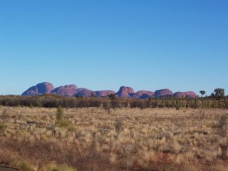
After the sunrise at Uluru we headed out to Kata Tjuta, formerly The Olgas. These are a bunch of rocks about 40 km to the west of Uluru. They're just as tall as Uluru, but they're more spread out and, most importantly, aren't a single chunk of rock, but several chunks sticking up from the earth. I reckon they're more impressive than Uluru but, not being a single chunk of rock above the ground, they just can't get the same recognition.
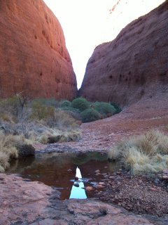
We went on the shortest, easiest walk there was, which lead in between the biggest mound, Mount Olga, and another big one adjacent to that. It must've rained recently as there were pools of water sitting inside. These two rock mounds are connected by all the pieces of the rock that have eroded off and other bits and pieces that have blown in. Surprisingly, that's plenty for vegetation to get a hold.
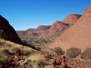
Dad and I wanted a different view (Mum didn't want to walk any more), so the two of us briskly went up a different path. Well, Dad went briskly—I was barely able to keep up—but the view from the path as far as we got was quite nice. From here you could see the other mounds that make up Kata Tjuta. A bit more actual dirt has made its way in between these mounds, probably because they aren't as tall, so more vegetation is about.
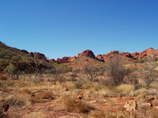
At the end of the day, we drove out towards King's Canyon, about 300 km from Yulara, where we stayed overnight. The next morning we headed out from the caravan park to the canyon itself. It's a canyon—what can I say? There's a big rocky slot in the ground that water tends to run through. I suppose that's pretty canyony.
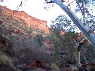
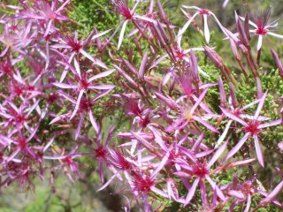
Lot's of vegetation and pretty red rocks along the canyon walk. Once we'd had a good look around we headed back to Alice Springs, nearly 500 km by road. (It's less in a straight line, but the only passable road goes south, then east, then north, so it's that much longer.) Overnighted there, once more.
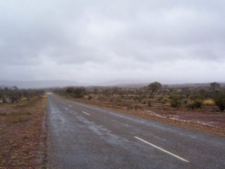
Contrary to popular belief, it does actually rain in the Red Centre sometimes. It started pouring down on us as we headed out to Ormiston Gorge. You can see it all over the road, here, with water running over a floodway in the distance. They don't seem to bother building many bridges in NT; I figure that's because bridges are either not needed in the dry season, or they are likely to be washed away in the wet season. So in the event that it does rain they just let it flow over the road and leave it to tourists to figure out for themselves.
Ultimately, Ormiston Gorge got washed out for us. It was too wet to go on any walks (the rain gear we had was useless) so we just had lunch in the van, took a couple of photos of the gorge in the clouds, and then headed back to Alice Springs. We were going to detour to look at the Ochre Pits nearby, but the walking track became flooded just as we arrived. Probably better than it flooding while trying to get back, at least.
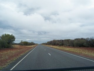
After another night at Alice Springs we headed north towards Tennant Creek. This was one of the longest stretches of driving of the trip. The roads in this part of the country are insane—you can drive for a good ten minutes towards the horizon at 100 km/h without seeing a single corner or crest in the road. It's like that most of the way from Alice Springs to Darwin, and being signed as open roads, there was no speed limit (which, due to new laws in NT, is no longer the case). The van couldn't do much over 110 km/h, anyway, so that was moot.
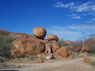
Along the way to Tennant Creek we passed the Devil's Marbles, a collection of large almost spherical rock formations over a region a couple of hundred meters in diameter. A whole lot of red spherical rocks, most about four meters in diameter sit in piles about the place. It's a bizarre formation.
We spent the night in Tennant Creek, and in the morning headed over to another old telegraph station. See above, they're pretty much the same. Except this one's even more remote.
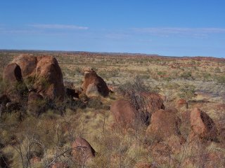
After that we headed along another nasty dirt road to the Pebbles. The Pebbles seem to be the same kind of formation as the Devils Marbles but in a later stage of erosion. The rocks are smaller (about a third of the size on average, I would guess), but there are many more of them strewn about over a larger region. I wouldn't be surprised if they were more impressive at the same stage as the Devils Marbles are at now.
With another 550 km of mind-numbingly straight road, we ended up at Mataranka, where we stayed overnight. Twenty kms out of Mataranka is the Mataranka Thermal Pool. It's very clear and, apparently quite warm. None of us tried swimming in it, though there is a spot where you're allowed to.
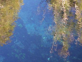
The water is so clear in some parts of the thermal pool that you can easily see the bottom a couple of meters below. And then, some of the water is covered in algae and is just a swampy marsh that you can't see through at all. Go figure.
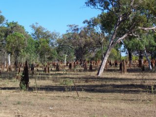
Just outside the caravan park is a couple of fields of termite mounds. There are thousands of these mounds, and you can almost judge how far north you've come by how tall the mounds are. The taller the mound, the further north you are. These mounds are all about a meter to a meter and a half tall. No idea where they get all their food from—there aren't that many trees around. Perhaps they're why...
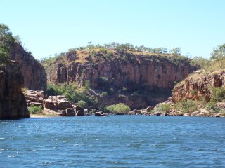
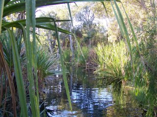
Another 100 km and over in Nitmiluk Gorge we took a short guided cruise up the river through the gorge. Now that we're nearer the ocean the creaks and rivers are seeming fuller. Perhaps it was the fact that we hadn't seen any decent river since we left home, but this one seemed actually reasonably well filled for our arrival.
Mind you, it gets a whole lot more filled than that in the wet season. The entire river is accessible by boat, then, but in the dry (when we arrived) the water is too low, and parts of the river are cut off by rocks on the river bed rising out of the water. We had to get out of one boat, walk along a couple hundred meters, then get into another boat to continue the cruise.
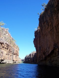
It's neat to see water actually seeping through and out of the rocks that wall the gorge. You can see it dripping out under rock ledges.
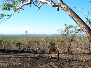
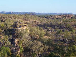
200 km further on the road and into Kakadu National Park, we stop at Bukbukluk Lookout. Interestingly, we expected to have to pay to enter Kakadu, like we did at Uluru, but it turns out that entrance fees have been dropped since December 2004. Chalk another win to procrastination on our part!
The climate here is very much different from that at Alice Springs. It's almost unbearably hot (35 ℃—winter, mind you; if they call that winter, buggered if I'll hang around to see what summer is like), and the vegetation is greener and more tropical. That, and the mozzies are out. The wads of warm gear Mum insisted we pack ended up just wasting space, especially once we entered the heat of the top end.
We spent the night at Jabiru up in the north east of Kakadu. It was about this time that we discovered the van fridge was dying. In the middle of the night it started making loud gurgling noises and stopped cooling its contents, so we had to turn it off and keep it stacked with ice for the rest of the trip.
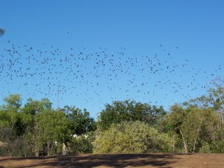
While driving out to the Yellow Water Billabong that morning we come across a colony of flying foxes. Same as we have back home. We came thousands of kilometers to see something we've got at home, and end up declaring that our colony is bigger. There's got to be something wrong with that.
Our's is bigger, though.
Anyway, another cruise, this time on the Yellow Water Billabong. We saw some crocodiles, some trees, some water, and a bunch of lilies. I wasn't as impressed as I was with the first cruise, and the guide wasted a whole bunch of time on an “audience participation” bit that she could've finished in a third as long. I'm not big on audience participation, but then, the oldies seem to enjoy it.
We took this photo on a walk before the cruise. The walk went beside the river for a bit, then out through nowhere for most of the rest of the way. We went well beyond the point in the path that was actually worth going to, so it's no wonder we were stuffed by the end of the day.
That afternoon we drove to Ubirr right in the very north-east corner of Kakadu. We saw some old Aboriginal creation-myth paintings and listened to a ranger talk about it. The story goes that this god-mother type being came along over the flat, formless land, making hills and rivers, planting trees, animals and people, and as she went along she left this mark in the rockface. Yeah, they didn't paint it—it's a mark left by the creator herself. About as believable as anyone else's creation myth, really.
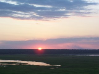
We stayed there to watch the sunset from high on a rocky outcrop. Very pretty watching the sun shine over the wetlands below. After sunset, rangers kick all us whiteys off—it's literally illegal for us to be there in the dark hours.
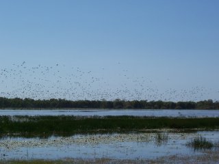
Another night in Jabiru, then we wandered over to Mamukala Wetlands. It's a big area of swampy marshy wet stuff with thousands of birds swimming and feeding. In the photo are a bunch of the birds of the wetlands, stirred up by some guy in an airboat roaring around. I would've called him a bloody idiot for ruining the atmosphere. I'm not sure what he was attempting to do, but stirring up the birds was, at least, one of the consequences.
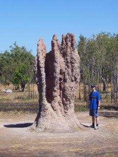
Making our way westwards to Berry Springs we came across the biggest termite mound we spotted during the trip. Don't mind the nerd on the right—that's just me. I'm there for height reference. I'm 1.8 m tall, and the mound is at least twice as tall as me, so it's at least 3.6 m tall. While that's damn impressive, apparently they can get as high as five meters.
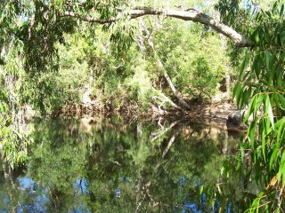
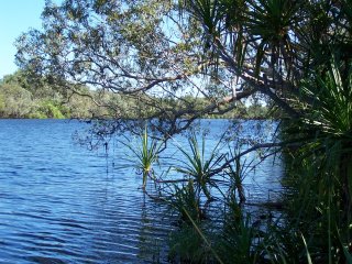
Eventually we ended up at Berry Springs, and for the rest of the day we did pretty much nothing. It was too hot and we were too tired, so we just lay around recuperating from the last couple of days. Dad went out to the nearby billabong and took this photo. We overnighted in Berry Springs.
The first half of the next day was spent at the Territory Wildlife Park. It's pretty much a zoo of the local flora and fauna. Kangaroos, wallabies, various reptiles, birds, marsupials, plants, etc. The wallabies (and some roos, I think) were in an enclosure that you walked around with them in.
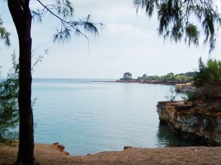
Finally we ended up at the coast in Darwin. We didn't do much other than wander around the parks at the coast and the shopping areas. Darwin's airport is right in the middle of the city, so sleeping that night was... interesting. Or so I'm told. Every four hours or so planes roared overhead. Or so I'm told. I actually managed to sleep through almost all of it.
The next morning we packed up ready to head back to Brisbane out of Darwin. At the end of the trip we had too many supplies and were busily giving things away and throwing other things out. (I had a feeling we had gotten too much stuff, but what would I know?)
Hectic and somewhat cramped (figuratively and literally), but it was a great trip and wonderful to see the highlights of the Northern Territory. It's definitely a pretty part of the world and well worth seeing—I'll happily keep the photos—but the remoteness and heat is something I wouldn't be able to bear on more than a temporary basis. In that sense, think we did it the right way.
Comment to add? Send me a message: <brendon@quantumfurball.net>